
Introduction
In the quest for sustainable solutions to address global environmental challenges, OpenET has emerged as a groundbreaking system utilizing NASA satellite data for precise water management. OpenET, an acronym for Open Evapotranspiration, relies on an ensemble of six satellite-driven models, predominantly drawing from the Landsat program’s data. The recent evaluation of OpenET’s accuracy, particularly in tracking evapotranspiration over agricultural areas, is paving the way for transformative changes in water resource management practices worldwide.
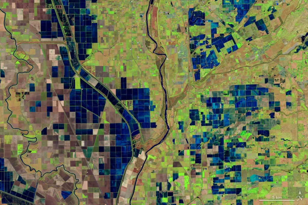
This captivating image, captured on December 26, 2018, features a false-color representation using the Operational Land Imager (OLI) on Landsat 8. It vividly displays the flooded rice fields lining the Sacramento and Feather Rivers. Immersed fields are depicted in deep blue, while the lush vegetation stands out in vibrant green hues. Courtesy of NASA Earth Observatory, photographed by Lauren Dauphin.
The Intricacies of Evapotranspiration
Evapotranspiration, the invisible process involving the movement of water vapor from soil and plant leaves into the atmosphere, plays a pivotal role in determining water availability for crops and plants. While traditional methods relied on estimates of potential evaporation based on weather data or localized information from ground-based stations like flux towers, OpenET takes a revolutionary approach by leveraging the consistent monitoring capabilities of satellites.
Example: Consider a scenario where traditional methods of estimating evapotranspiration might lead to inaccuracies due to the limited coverage of ground-based stations. OpenET, with its satellite-driven models, provides a broader and more accurate perspective, essential for effective water management.
Satellite Technology: Landsat 8 and 9
The backbone of OpenET lies in the Landsat 8 and 9 satellites, a collaboration between NASA and the U.S. Geological Survey. These satellites offer valuable data on land surface temperatures and the health of vegetation, enabling high-resolution calculations of evapotranspiration at a field-level scale.
Example: In regions with diverse landscapes, such as Northern California’s Sacramento-San Joaquin Delta, Landsat satellites consistently capture data, allowing water resource managers to make informed decisions based on accurate evapotranspiration calculations.
Study Results and Agricultural Implications
The recent large-scale analysis, led by John Volk of the Desert Research Institute, revealed OpenET’s exceptional accuracy, especially in western arid regions crucial for agriculture. The system demonstrated a high level of precision in calculating evapotranspiration for various crops, including wheat, corn, soy, and rice.
Example: For farmers in water-scarce regions, such as parts of California, OpenET’s accuracy becomes a crucial tool. Water resource managers in the Sacramento-San Joaquin Delta can now confidently use OpenET data to ensure farmers comply with state regulations, leading to more sustainable water use.
Practical Impact on Water Management
Accurate evapotranspiration data is invaluable for making informed decisions regarding irrigation needs, ultimately contributing to cost savings and sustainable water management practices. The positive results of the study instill confidence in water resource managers, like Lindsay Kammeier of the California State Water Board, who emphasized the role of precise data in managing the environment, agricultural practices, and urban water use.
Example: OpenET allows farmers to optimize irrigation practices by providing real-time data on crop water requirements. This, in turn, helps conserve water resources and reduces unnecessary expenses associated with over-irrigation.
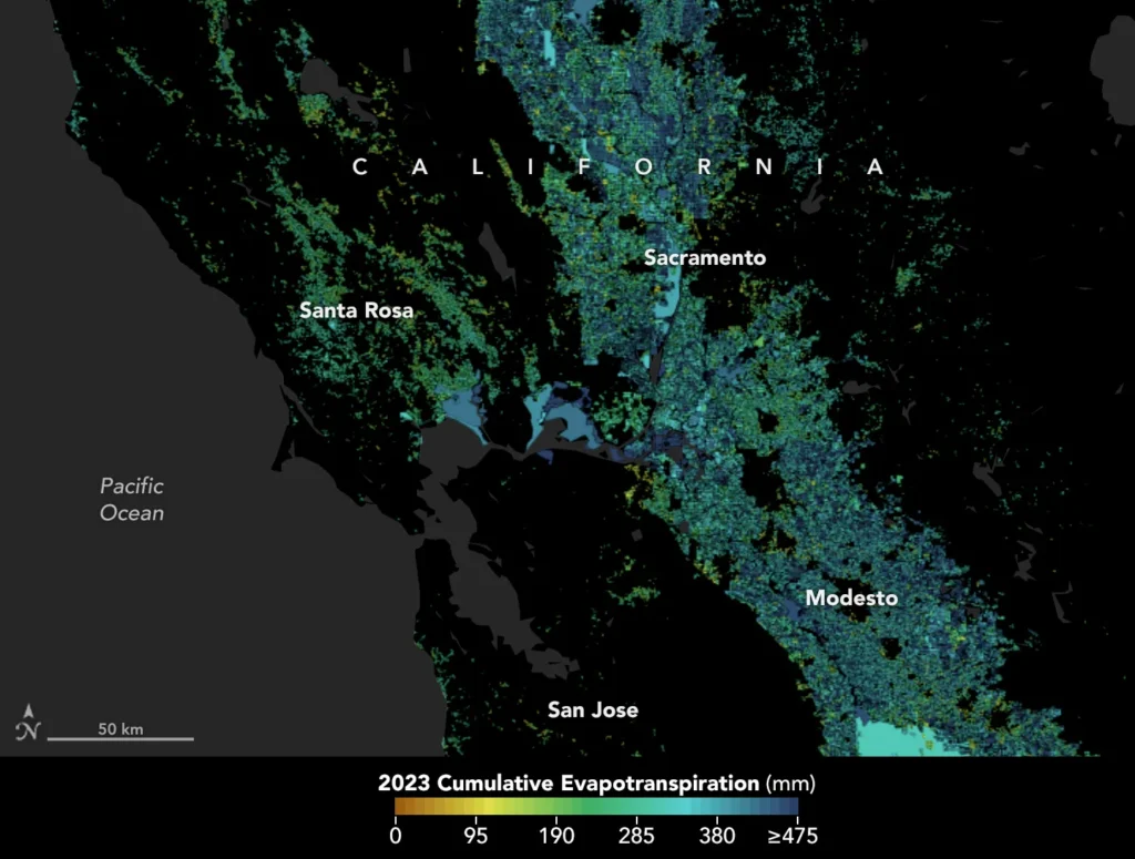
In California, state authorities and agricultural practitioners leverage satellite data via OpenET to monitor evapotranspiration, gaining valuable insights for improved water resource management. This approach provides a transparent view of the water utilized by plants and crops, particularly those cultivated in the fertile expanse of the Central Valley. Image courtesy: NASA Earth Observatory, sourced from openetdata.org.
The Collaborative Success of the OpenET Consortium
The success of OpenET can be attributed to the collaborative efforts of the OpenET consortium, which includes NASA, the U.S. Geological Survey (USGS), the U.S. Department of Agriculture, the Desert Research Institute, and various universities. The Environmental Defense Fund and Google Earth Engine contribute significantly to this collaborative initiative, showcasing the importance of interdisciplinary cooperation in addressing complex environmental challenges.
Example: The collaboration ensures that OpenET’s data and models are robust and reliable. The involvement of experts from diverse fields ensures a comprehensive approach to water resource management, considering both environmental and agricultural perspectives.
Conclusion
As OpenET continues to evolve, its role in promoting sustainable water use practices becomes increasingly significant on a global scale. By harnessing the power of NASA satellite data, OpenET provides a transformative solution to the challenges of tracking evapotranspiration accurately. The collaborative efforts of the OpenET consortium exemplify the importance of interdisciplinary cooperation in addressing complex environmental challenges. As OpenET becomes a cornerstone in water resource management, its impact is poised to extend beyond local applications, contributing to the global conversation on sustainable water practices.
For more information, go to: https://openetdata.org/
Source : https://science.nasa.gov/science-research/earth-science/water-energy-cycle/openet-moisture-measurement-tool-is-proving-highly-accurate/